Antique World Map — Higden’s Mappa Mundi, Jomard Facsimile



Description
An antique world map: Higden’s mappa mundi in Jomard’s facsimile
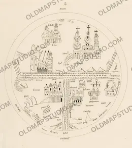
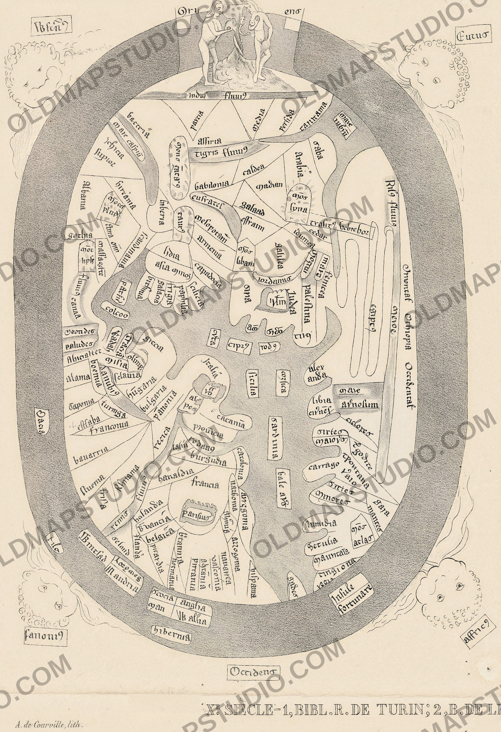
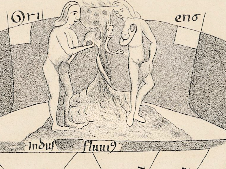
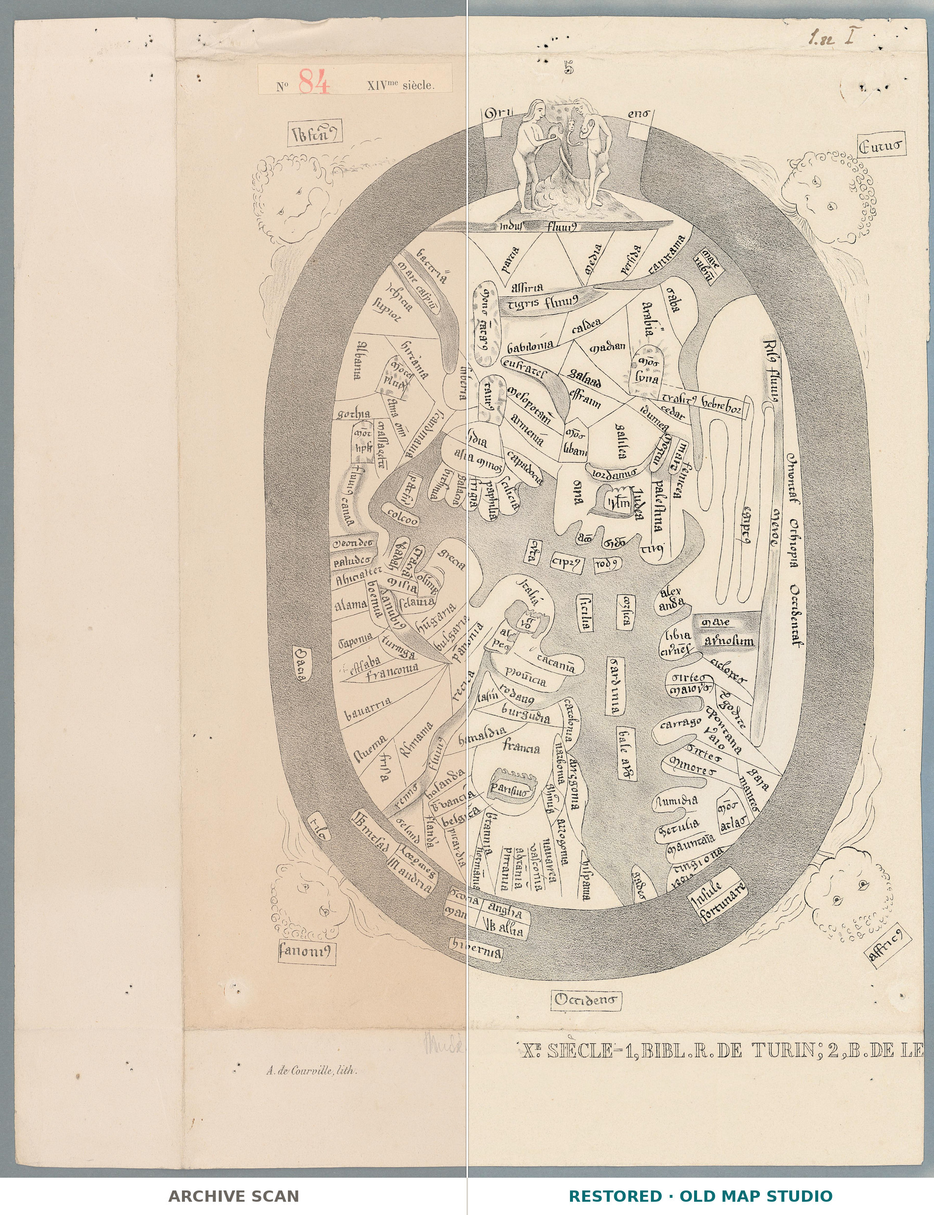
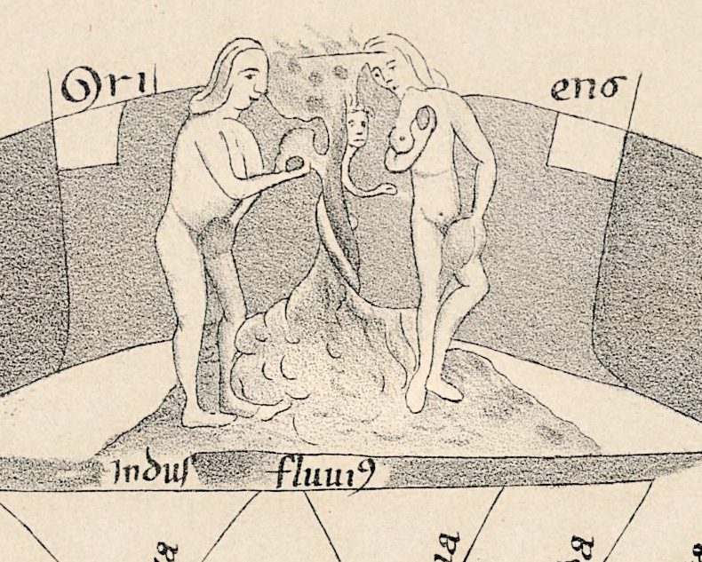
The world on this sheet is an oval. A dark band of Ocean runs all round it, and east is at the top: the word for east is split across the top of the band into Ori and ens, and Occidens, the west, is written below the oval. At the very top, above the river Indus, stand Adam and Eve, with a small figure with a human face in the tree between them. Wind heads blow towards the Ocean from the corners of the sheet.
A label above the map reads No 84 XIVme siècle, and the library record calls the map [Mappemonde d’Higden]. Ranulf Higden (c. 1280–1364), in Britannica’s account, took monastic vows in 1299, entered the Benedictine Abbey of St. Werburgh in Chester and wrote the Polychronicon, a universal history from the Creation to his own time in seven books, modeled on the seven days of Creation. Winchester College notes that the copies of the Polychronicon with this map make up almost a quarter of the surviving medieval mappae mundi.
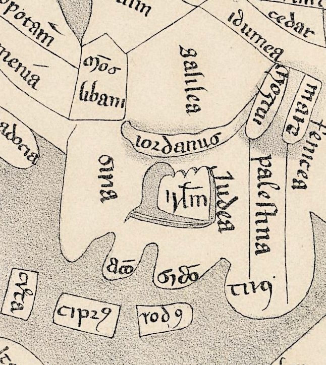
The National Library of Scotland, describing the Higden map in its own fifteenth-century manuscript, explains that it moved from the circular T-O form to an ovoid shape, with east at the top. The Huntington Library’s copy of the Polychronicon (HM 132), made in England between 1340 and 1360, has an oval map with Jerusalem at the center, the ocean around the edge and Adam and Eve with the serpent in the tree at the top. The same pattern is here: a walled city in Iudea, its short name marked with a bar of abbreviation, stands near the middle of the oval, with the river iordanus just above it, while the British Isles sit in the Ocean band at the bottom.
The sheet itself was printed in the nineteenth century. It is a plate from Les monuments de la géographie, in which Edme-François Jomard (1777–1862) published old maps in facsimile at the size of the originals. The Bibliothèque nationale de France names him the first curator of the map department created at the Royal Library in Paris in 1828. According to the Royal Geographical Society of South Australia, the first instalment of the atlas appeared by 1842 and more followed until 1862. The Geneva record notes “Dessin de Jomard” and gives the imprint as Paris, Duprat, with the year left open as [18--?]; its date field reads 1800, which we repeat in the specifications as given. The plate is signed at the lower left A. de Courville, lith. Neither the record nor the sheet says which manuscript Jomard copied.
What to look for on the sheet
- Adam and Eve at the top of the oval, between Ori and ens, above Indus fluui(us).
- The walled city in Iudea, with palestina, galilea and the river iordanus around it.
- At the upper right, the Red Sea, mare rubrū, and below it the label trasit(us) hebreho(rum) — the crossing of the Hebrews — near Nil(us) fluui(us).
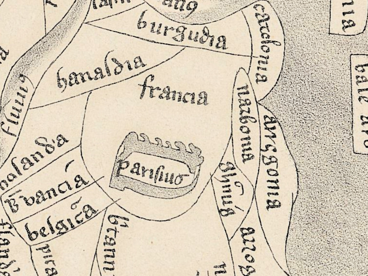
- parisius, Paris, drawn as a walled town in francia.
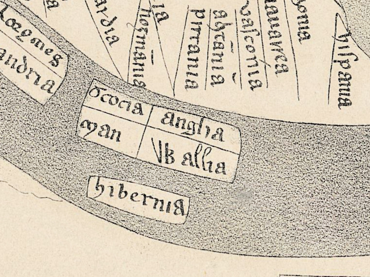
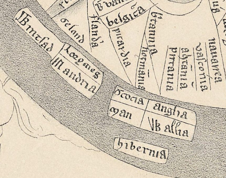
- The British Isles in the Ocean band at the bottom: scocia, anglia, man, Wales and hibernia; and Insule fortunare, the Fortunate Isles, at the lower right.
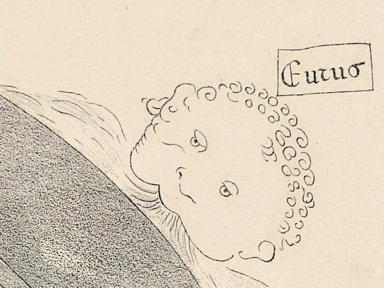
- Wind heads in the corners, two of them labeled Eurus and affric(us).
David Woodward, in the first volume of The History of Cartography, credits Jomard with a rival facsimile atlas that contained thirty medieval world maps, beside the 117 mappaemundi of Santarém’s atlas of 1849. After Jomard’s death his colleague Armand d’Avezac put the set in its final order; his inventory of the Monuments de la géographie was printed in Paris in 1867.
Everything on this sheet: full record
Every inscription on the sheet
The map imitates a Gothic book hand, in which capitals and small letters are not always distinct; names are given letter for letter as they stand, in small letters unless a capital is clear, and the long s is printed as s. The medieval sign for -us, a raised hook like a small 9, is written as (us); the sign for -rum as (rum); a letter under a bar of abbreviation keeps its bar (ū, ō). Names that could not be read with confidence are described, not guessed. Inside the oval only the larger names are listed.
- Upper margin, on a separate slip: No 84, the number in red, and XIVme siècle. [fourteenth century]. To the right of it, above the map: a small numeral 5. Upper right corner, in pencil: 1.82 and I.
- On the Ocean band at the top: Ori and ens [Oriens, east], one on each side of the Paradise scene. Below the oval: Occidens [west].
- Wind heads in the corners: upper left, a label of five or six Gothic letters ending in the -us sign, not read with confidence; upper right Eurus; lower right affric(us) [Africus]; lower left fanoni(us) [for Favonius].
- Top of the oval: Adam and Eve and the tree, with a small figure with a human face in it, without a name; below them Indus fluui(us) [the river Indus].
- Asia: parcia, media, persida, mare caspiū [Caspian Sea], assiria, Tigris fluui(us), babilonia, caldea, eufrates, armenia, gothia.
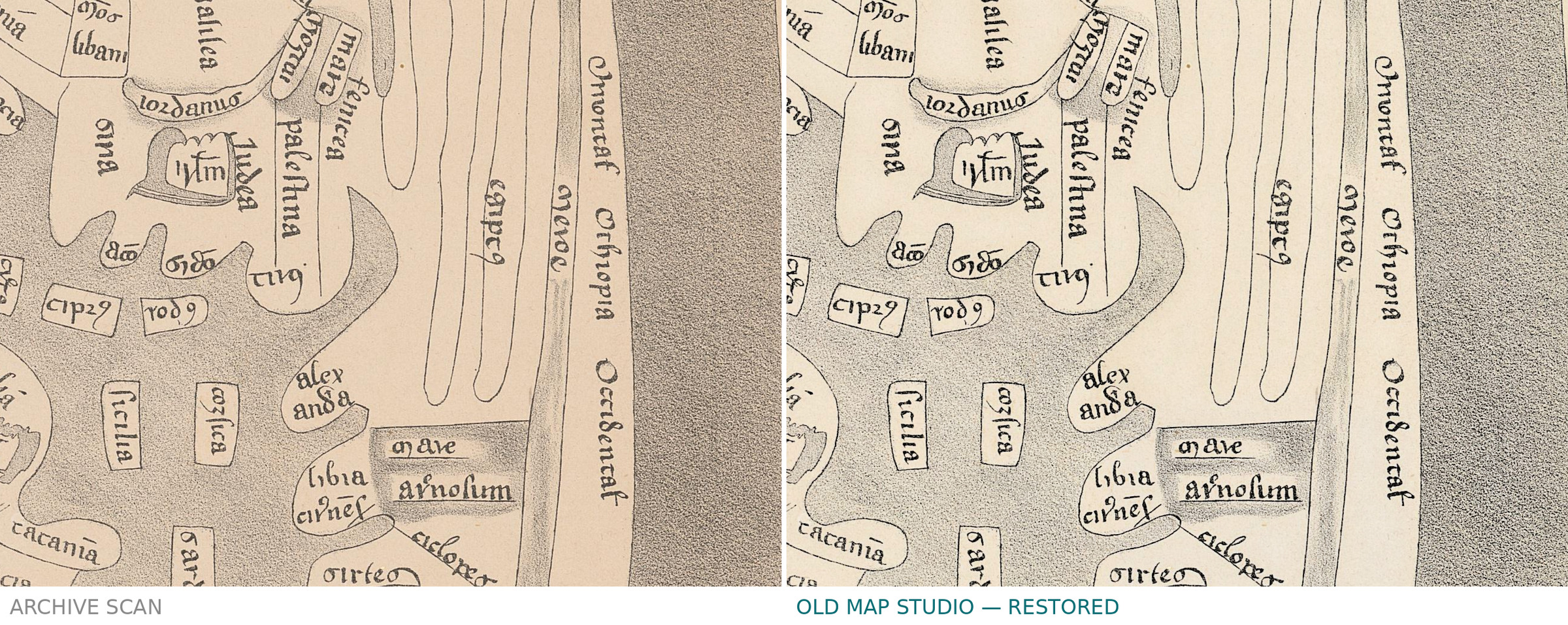
- The Holy Land: a walled city with a short name under a long bar of abbreviation; around it Iudea, palestina, galilea, iordanus [the Jordan], idumea and cedar; in the sea below, creta, cipr(us) and rod(us).
- The Red Sea and Egypt, upper right: mare rubrū [Red Sea], saba, arabia, mōs syna [Mount Sinai], trasit(us) hebreho(rum) [crossing of the Hebrews], Nil(us) fluui(us) [the Nile].
- Africa, right and lower right: libia, mare arnosum, numidia, getulia, mauritāia, gara-mantes on two lines, mōs atlas [Mount Atlas], gades.
- Europe, lower left: grecia, sicilia, corsica, sardinia, burgudia, francia with parisius inside a walled outline, belgica, picardia, bauarria, franconia; in Italy a walled town whose short name is unclear.
- The Ocean band, left and bottom: Dacia; a short name beginning Til, its end unclear; at the bottom scocia, man, anglia, VB allia as drawn [Wallia, Wales] and hibernia; at the lower right Insule fortunare [the Fortunate Isles].
- Lower margin: A. de Courville, lith. at the left; at the right, in hollow capitals, Xe SIÈCLE—1, BIBL. R. DE TURIN; 2, B. DE LE, cut off at the edge of the sheet.
The sheet does not agree with itself in two places. The slip above the map gives the fourteenth century, while the printed line in the lower margin speaks of the tenth century and of a map in the royal library of Turin: it does not describe this map, and it breaks off at the right edge. The islands at the lower right are written Insule fortunare, with an r where the Latin name has a t.
Editions and other known copies
- Bibliothèque de Genève, BGE Musée cartogr. 1/84: this copy, published on e-rara under the Public Domain Mark, DOI 10.3931/e-rara-91533. The DOI record gives the title as Monuments de la géographie ou Recueil d’anciennes cartes européennes et orientales … / [Mappemonde d’Higden], names Jomard, Edme-François, and notes “1 carte ; 29 x 20 cm”, “Dessin de Jomard” and “Paris : Duprat, [18--?]. - 13/5”; its publication year field reads 1800.
- Bibliothèque nationale de France: Les monuments de la géographie … publiés en fac similé de la grandeur des originaux par M. Jomard, Paris, Duprat, [1846-1862], one large folio volume. The record lists copies, among them in the map department (GE CC-1232, two bound copies, one of them in the Réserve; GF 912.22 JOMA m, plates in a portfolio), at the Société de Géographie (FOL-SG D2-83 and D2-83 (BIS)) and at the Arsenal (FOL-NF-10149). It does not list single plates.
- Royal Geographical Society of South Australia: a copy of the atlas, which the Society describes as hand-coloured lithographs; it gives 1854 as the official date of the work, the first instalment by 1842 and further ones through 1862. That description belongs to its copy.
- Armand d’Avezac, Inventaire et classement raisonné des “Monuments de la géographie” par M. Jomard, Paris, E. Donnaud, 1867, eight pages, an extract from the bulletin of the Académie des inscriptions et belles-lettres (session of 30 August 1867); recorded in the libraries of the French Ministry of Defence.
- Manuscripts of the Higden map named in the sources for the story: Huntington Library, HM 132, folio 4v (England, 1340–1360); National Library of Scotland, Adv.MS.33.4.12 (fifteenth century, colored, 22 × 30 cm); British Library, Royal MS 14 C IX, with two maps; and the copy at Winchester College. None of these is named as the model of Jomard’s plate.
- None of these records names states of the plate. The dates differ: 1800 in the date field of the Geneva record and [18--?] in its imprint, [1846-1862] at the Bibliothèque nationale de France, 1842 to 1862 for the instalments according to the Royal Geographical Society of South Australia.
Catalog entries and sources
Bibliothèque de Genève, BGE Musée cartogr. 1/84; e-rara 26117936; DOI 10.3931/e-rara-91533; 13/5 in the record. Bibliothèque nationale de France, record FRBNF40701189. Sources for the story and this record: the DataCite record of DOI 10.3931/e-rara-91533; the Bibliothèque nationale de France catalogue and its page on Edme-François Jomard; Britannica, “Ranulf Higden”; Winchester College, “Ranulf Higden, Polychronicon, late 14th century”; National Library of Scotland, record of Adv.MS.33.4.12; Digital Scriptorium, record of Huntington Library HM 132; C. Dreer and K. D. Lilley, “Universal Histories and their Geographies: Navigating the Maps and Texts of Higden’s Polychronicon” (2017); D. Woodward, “Medieval Mappaemundi”, in The History of Cartography, vol. 1; Royal Geographical Society of South Australia, “Jomard Atlas 1854”; the 1867 inventory by d’Avezac as recorded in the French Ministry of Defence libraries.
This copy
The plate is printed in black and grey on cream paper, with the Ocean band and the seas shaded in a grey stipple; there is no color. A long vertical line runs the full height of the sheet near its left edge, and a horizontal crease crosses the lower margin just above the printed line about Turin. Small dark specks are scattered over the margins. The number slip at the top is a separate piece of paper; the pencil 1.82 and I are not part of the printed plate. Both lie outside the trimmed frame of the file, while the lithographer’s line and the cut-off caption lie inside it and were kept.
Your file
| Original | Edme-François Jomard, Les monuments de la géographie, Paris: Duprat, [18--?]; plate [Mappemonde d’Higden], 13/5 in the record; lithograph signed A. de Courville; 29 × 20 cm; Bibliothèque de Genève, BGE Musée cartogr. 1/84 |
| Scan | full sheet 3589 × 4524 px; the map inside the trimmed border 2585 × 3772 px |
| Print size at 300 dpi | the map prints to 31 cm (12 in), the full sheet with margins to 38 cm (15 in) |
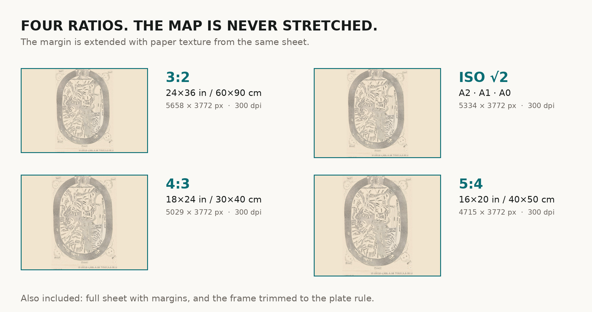
| You download | six ZIP archives: full sheet, trimmed, 3:2, 4:3, 5:4 and ISO A |
| Inside each one | one JPEG at 300 dpi, the restoration passport as a PDF, a READ ME |
How to print
- The sheet is upright and small: print it at 300 dpi at the size above and do not let the shop scale the file up.
- Pick the archive whose proportions match your frame, so nothing is cropped or stretched.
- Ask for matte fine-art paper, sRGB, auto-enhancement off.
- Where to print it: print shops near you and checked prices at online labs.
Source and rights
The file is made from the Bibliothèque de Genève scan published on e-rara, shelfmark BGE Musée cartogr. 1/84, DOI 10.3931/e-rara-91533, under the Public Domain Mark. The library asks that reproductions name the author, the place and the DOI: Edme-François Jomard, Bibliothèque de Genève, 10.3931/e-rara-91533. The record does not state the coloring or the printing technique; the lithographer’s signature is on the sheet. The paper tone was evened and one spot in the margin removed; the printed lines were not touched. There is no TIFF master in the package. Catalogue record: e-rara (Bibliothèque de Genève) →
Questions
How large can I print it?
The map to 31 cm (12 in) on the long side at 300 dpi, the full sheet with margins to 38 cm (15 in), from the scan’s own resolution, not an upscale. It suits a small frame.
Is this a medieval manuscript?
No. It is a nineteenth-century lithographed facsimile from Jomard’s atlas of a fourteenth-century world map of the kind found in copies of Higden’s Polychronicon. Neither the record nor the sheet names the manuscript Jomard copied.
Why is east at the top?
Higden maps put east at the top, as the National Library of Scotland notes. Here Ori and ens stand at the top of the oval and Occidens below it.
Why does the specification say 1800?
The library record gives 1800 in its date field and [18--?] in the imprint; the atlas came out in instalments between 1842 and 1862, according to the Royal Geographical Society of South Australia. We repeat the record’s date and add no dating of our own.
What is the printed line below the map?
Part of a caption in hollow capitals, Xe SIÈCLE—1, BIBL. R. DE TURIN; 2, B. DE LE, cut off at the edge of the sheet. It speaks of tenth-century maps, not of this one. It lies inside the trimmed frame and was kept, like the lithographer’s line A. de Courville, lith.
Features
- Latin
Attachments
Reviews
No reviews found